NRAA Explores Satellite and Drone Technologies to Strengthen Watershed Planning Under REWARD Programme
Brainstorming workshop in Jaipur focuses on integrating geospatial technologies into India's next-generation watershed management framework under WDC-PMKSY 3.0. Key Highlights National Rainfed Area Authority (NRAA) organised a high-level workshop on satellite and drone-based watershed planning in Jaipur. Workshop
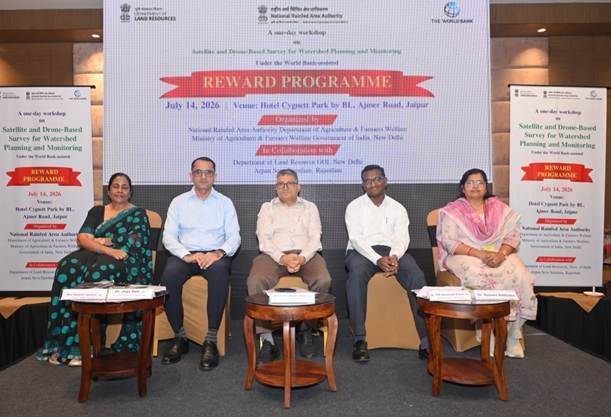
Brainstorming workshop in Jaipur focuses on integrating geospatial technologies into India’s next-generation watershed management framework under WDC-PMKSY 3.0.
Key Highlights
- National Rainfed Area Authority (NRAA) organised a high-level workshop on satellite and drone-based watershed planning in Jaipur.
- Workshop held under the World Bank-supported REWARD Programme.
- Experts discussed the use of geospatial technologies for watershed planning, implementation, monitoring and evaluation.
- Recommendations will contribute to the National Technical Guidelines (NTG) for WDC-PMKSY 3.0.
- Officials from Central and State governments, research institutions, industry and NGOs participated.
- Focus on improving agricultural resilience, water conservation and sustainable natural resource management.
NRAA Pushes for Satellite and Drone-Based Watershed Management to Boost Climate-Resilient Agriculture
New Delhi, July 16: The National Rainfed Area Authority (NRAA) has initiated efforts to modernise India’s watershed development programmes by exploring the use of satellite imagery and drone technology for planning, monitoring and evaluation under the World Bank-assisted REWARD (Rejuvenating Watersheds for Agricultural Resilience through Innovative Development) Programme.
A high-level brainstorming workshop held in Jaipur, Rajasthan, brought together policymakers, scientists, technical experts and state officials to deliberate on integrating advanced geospatial technologies into India’s watershed management framework.
Technology to Improve Watershed Planning
The workshop focused on leveraging satellite-based mapping and drone surveys to improve the scientific planning, implementation and monitoring of watershed development projects.
Participants discussed how geospatial technologies can provide accurate data for:
- Watershed mapping
- Land-use planning
- Soil and water conservation
- Monitoring project implementation
- Performance evaluation
- Natural resource management
The recommendations are expected to contribute to the preparation of the National Technical Guidelines (NTG), which will serve as an important reference for the upcoming Watershed Development Component of PMKSY (WDC-PMKSY) 3.0.
Standardised National Framework
Addressing the workshop, NRAA Chief Executive Officer Dr. Chandra Shekhar Kumar emphasised the need for clear national guidelines on when and how satellite imagery and drone-based surveys should be deployed across different agro-climatic regions.
He stressed that standardised methodologies would improve the quality, transparency and effectiveness of watershed planning, implementation, monitoring and impact assessment.
Broad Participation from Stakeholders
The workshop witnessed participation from representatives of:
- Central Government ministries
- State watershed departments
- Panchayati Raj institutions
- National research organisations
- Technical experts
- Industry representatives
- Non-governmental organisations
Senior officials from Rajasthan, Andhra Pradesh, Maharashtra and various national institutions shared experiences on adopting emerging technologies for sustainable watershed management.
Supporting Climate-Resilient Agriculture
The REWARD Programme aims to strengthen agricultural resilience by promoting scientific watershed development, efficient water management and sustainable use of natural resources in rainfed regions.
By integrating satellite and drone technologies, the programme seeks to improve project planning accuracy while enabling real-time monitoring and evidence-based decision-making for future watershed interventions.
The deliberations are expected to help shape India’s next-generation watershed development strategy under WDC-PMKSY 3.0, with greater emphasis on technology-driven resource management and climate adaptation.
Impact on Hospitality, Food Processing and Tourism
Although primarily focused on agriculture and natural resource management, improved watershed development has significant long-term benefits for the hospitality, food processing and tourism sectors. Better water conservation and sustainable land management enhance agricultural productivity, ensuring a more reliable supply of fruits, vegetables, cereals and other raw materials for hotels, restaurants and food processing industries.
Healthy watersheds also contribute to the restoration of rivers, lakes and rural landscapes, creating opportunities for eco-tourism, rural tourism and nature-based travel. Improved water availability supports agritourism destinations, farm stays and local food experiences while strengthening the resilience of rural communities that increasingly participate in tourism-related enterprises.
The adoption of satellite and drone technologies further promotes sustainable land-use planning, helping preserve natural ecosystems that are essential for biodiversity, outdoor recreation and environmentally responsible tourism development.